Address: 1 (From 1 To 99) PEARSON WAY, EPPING, NH 03042-2438, USA
What's 03042-2438? 03042-2438 is a ZIP Code 5 Plus 4 number of 1 (From 1 To 99) PEARSON WAY, EPPING, NH, USA. Below is detail information.
03042-2438 Basic Information

-
ZIP Code 5 Plus 4:
03042-2438 -
ZIP Code 5:
03042 -
Plus 4?24384-digits that are used to identify a geographic segment within the 5-digit delivery area, such as a city block or a group of apartments or an individual high-volume receiver of mail, or any other unit that could use an extra identifier to aid in efficient mail sorting and delivery. This code is the low end of the range of +4 Codes that pertain to this ZIP Code. ZIP+4 Codes associated with nondelivery areas are composed of valid ZIP sector numbers and "ND" for the ZIP segment number, for example 12345-12ND. Non-deliverable areas are areas to which the USPS does not deliver mail, such as vacant lots and land that borders railroad tracks. Mailers should not match an address identified as a nondelivery area. If you absolutely must have numeric characters in the Plus4Code column, you may treat "ND" values as "00" (zero zero).:
-
Country:
U.S. - United States -
State:
NH - New Hampshire -
County:
CountyFIPS: 33015 - Rockingham County -
City:
EPPING -
Street?PEARSON WAYThe official name of a street as assigned by a local governing authority. The Street Name column contains only the street name and does not include directionals (EAST, WEST, etc.) or suffixes (ST, DR, BLVD, etc.). This element may also contain literals, such as PO BOX, GENERAL DELIVERY, USS, PSC, or UNIT. Numeric street names that have numeric components that are four characters (or less) in length at are justified such that the low-order digit of the number is positioned in the fourth position of the street name column. This shift is made so that the numeric street names appear in numeric sequence.:
-
Street Suffix?WAYThe street suffix: For Example: ST = Street RD = Road DR = Drive LN = Lane:
-
Record Type?S: StreetAn alphabetic value that identifies the type of data in the record. Record type codes include the following: G = General delivery H = Highrise F = Firm S = Street P = PO box R = Rural route/highway contract:
Address

- Address Primary Low Number?
A house, rural route, highway contract box, or post office box number; the numeric or alphanumeric component of an address preceding the street name; the low-end address in a range of addresses. Often referred to as house number.: 1
- Address Primary High Number?
A house, rural route, contract box, or Post Office box number. The numeric or alphanumeric component of an address preceding the street name. The high-end address in a range of addresses. Often referred to as house number.: 99
- Address Primary Odd / Even Code?
Code that identifies the side or sides of a street for which a given address range is applicable. For street, highrise, firm and multi-carrier records, B = Both sides of a street, E = Even side of a street (even-numbered addresses in the range); O = Odd side of a street (odd-numbered addresses in the range). For general delivery, post office box, and rural route/highway contract records, this code will always be "B" (both).: Both of Odd and Even
- Primary Range: 1, 2, 3, 4, 5, 6, 7, 8, 9, 10, 11, 12, 13, 14, 15, 16, 17, 18, 19, 20, 21, 22, 23, 24, 25, 26, 27, 28, 29, 30, 31, 32, 33, 34, 35, 36, 37, 38, 39, 40, 41, 42, 43, 44, 45, 46, 47, 48, 49, 50, 51, 52, 53, 54, 55, 56, 57, 58, 59, 60, 61, 62, 63, 64, 65, 66, 67, 68, 69, 70, 71, 72, 73, 74, 75, 76, 77, 78, 79, 80, 81, 82, 83, 84, 85, 86, 87, 88, 89, 90, 91, 92, 93, 94, 95, 96, 97, 98, 99.
Please click the "More Address Examples" to view the whole list.
1 PEARSON WAY, EPPING, NH 03042-2438
2 PEARSON WAY, EPPING, NH 03042-2438
3 PEARSON WAY, EPPING, NH 03042-2438
4 PEARSON WAY, EPPING, NH 03042-2438
5 PEARSON WAY, EPPING, NH 03042-2438
6 PEARSON WAY, EPPING, NH 03042-2438
7 PEARSON WAY, EPPING, NH 03042-2438
8 PEARSON WAY, EPPING, NH 03042-2438
9 PEARSON WAY, EPPING, NH 03042-2438
10 PEARSON WAY, EPPING, NH 03042-2438
11 PEARSON WAY, EPPING, NH 03042-2438
12 PEARSON WAY, EPPING, NH 03042-2438
13 PEARSON WAY, EPPING, NH 03042-2438
14 PEARSON WAY, EPPING, NH 03042-2438
15 PEARSON WAY, EPPING, NH 03042-2438
16 PEARSON WAY, EPPING, NH 03042-2438
17 PEARSON WAY, EPPING, NH 03042-2438
18 PEARSON WAY, EPPING, NH 03042-2438
19 PEARSON WAY, EPPING, NH 03042-2438
20 PEARSON WAY, EPPING, NH 03042-2438
21 PEARSON WAY, EPPING, NH 03042-2438
22 PEARSON WAY, EPPING, NH 03042-2438
23 PEARSON WAY, EPPING, NH 03042-2438
24 PEARSON WAY, EPPING, NH 03042-2438
25 PEARSON WAY, EPPING, NH 03042-2438
26 PEARSON WAY, EPPING, NH 03042-2438
27 PEARSON WAY, EPPING, NH 03042-2438
28 PEARSON WAY, EPPING, NH 03042-2438
29 PEARSON WAY, EPPING, NH 03042-2438
30 PEARSON WAY, EPPING, NH 03042-2438
31 PEARSON WAY, EPPING, NH 03042-2438
32 PEARSON WAY, EPPING, NH 03042-2438
33 PEARSON WAY, EPPING, NH 03042-2438
34 PEARSON WAY, EPPING, NH 03042-2438
35 PEARSON WAY, EPPING, NH 03042-2438
36 PEARSON WAY, EPPING, NH 03042-2438
37 PEARSON WAY, EPPING, NH 03042-2438
38 PEARSON WAY, EPPING, NH 03042-2438
39 PEARSON WAY, EPPING, NH 03042-2438
40 PEARSON WAY, EPPING, NH 03042-2438
41 PEARSON WAY, EPPING, NH 03042-2438
42 PEARSON WAY, EPPING, NH 03042-2438
43 PEARSON WAY, EPPING, NH 03042-2438
44 PEARSON WAY, EPPING, NH 03042-2438
45 PEARSON WAY, EPPING, NH 03042-2438
46 PEARSON WAY, EPPING, NH 03042-2438
47 PEARSON WAY, EPPING, NH 03042-2438
48 PEARSON WAY, EPPING, NH 03042-2438
49 PEARSON WAY, EPPING, NH 03042-2438
50 PEARSON WAY, EPPING, NH 03042-2438
51 PEARSON WAY, EPPING, NH 03042-2438
52 PEARSON WAY, EPPING, NH 03042-2438
53 PEARSON WAY, EPPING, NH 03042-2438
54 PEARSON WAY, EPPING, NH 03042-2438
55 PEARSON WAY, EPPING, NH 03042-2438
56 PEARSON WAY, EPPING, NH 03042-2438
57 PEARSON WAY, EPPING, NH 03042-2438
58 PEARSON WAY, EPPING, NH 03042-2438
59 PEARSON WAY, EPPING, NH 03042-2438
60 PEARSON WAY, EPPING, NH 03042-2438
61 PEARSON WAY, EPPING, NH 03042-2438
62 PEARSON WAY, EPPING, NH 03042-2438
63 PEARSON WAY, EPPING, NH 03042-2438
64 PEARSON WAY, EPPING, NH 03042-2438
65 PEARSON WAY, EPPING, NH 03042-2438
66 PEARSON WAY, EPPING, NH 03042-2438
67 PEARSON WAY, EPPING, NH 03042-2438
68 PEARSON WAY, EPPING, NH 03042-2438
69 PEARSON WAY, EPPING, NH 03042-2438
70 PEARSON WAY, EPPING, NH 03042-2438
71 PEARSON WAY, EPPING, NH 03042-2438
72 PEARSON WAY, EPPING, NH 03042-2438
73 PEARSON WAY, EPPING, NH 03042-2438
74 PEARSON WAY, EPPING, NH 03042-2438
75 PEARSON WAY, EPPING, NH 03042-2438
76 PEARSON WAY, EPPING, NH 03042-2438
77 PEARSON WAY, EPPING, NH 03042-2438
78 PEARSON WAY, EPPING, NH 03042-2438
79 PEARSON WAY, EPPING, NH 03042-2438
80 PEARSON WAY, EPPING, NH 03042-2438
81 PEARSON WAY, EPPING, NH 03042-2438
82 PEARSON WAY, EPPING, NH 03042-2438
83 PEARSON WAY, EPPING, NH 03042-2438
84 PEARSON WAY, EPPING, NH 03042-2438
85 PEARSON WAY, EPPING, NH 03042-2438
86 PEARSON WAY, EPPING, NH 03042-2438
87 PEARSON WAY, EPPING, NH 03042-2438
88 PEARSON WAY, EPPING, NH 03042-2438
89 PEARSON WAY, EPPING, NH 03042-2438
90 PEARSON WAY, EPPING, NH 03042-2438
91 PEARSON WAY, EPPING, NH 03042-2438
92 PEARSON WAY, EPPING, NH 03042-2438
93 PEARSON WAY, EPPING, NH 03042-2438
94 PEARSON WAY, EPPING, NH 03042-2438
95 PEARSON WAY, EPPING, NH 03042-2438
96 PEARSON WAY, EPPING, NH 03042-2438
97 PEARSON WAY, EPPING, NH 03042-2438
98 PEARSON WAY, EPPING, NH 03042-2438
99 PEARSON WAY, EPPING, NH 03042-2438
Address Example
EPPING NH 03042-2438
UNITED STATES OF AMERICA
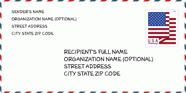
03042-2438 Envelope Example

-
This is an example of U.S envelope. Fill in the sender's information at the top left and the recipient information at the bottom right. The necessary information is sender/recipient's full name, street address, city, state and zip code. The recipient address information has been given for your reference. Generally, If you are not sure of the full 9-digit zip code, you can only fill in the 5-digit zip code to avoid loss of package.
03042-2438 Basic Meaning
-
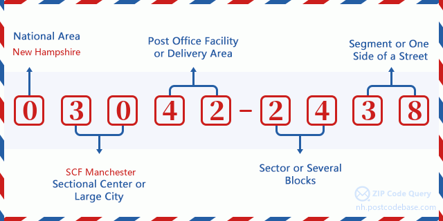
What does each digit of ZIP Code 03042-2438 stands for? ZIP+4 Code consists of two parts, the first five digits can be located to the post office, and the last four digits can identify a geographic segment within the five-digit delivery area. The 6-7 digits designate sector or several blocks, and the 8-9 digits designate segment or one side of a street.

- ·Carrier Route ID?
A 4-digit code assigned to a mail delivery or collection route within a 5-digit ZIP Code. The first character of this identification is alphabetical, and the last three are numeric: Bnnn = PO box Hnnn = Highway contract Rnnn = Rural route Cnnn = City delivery Gnnn = General delivery: R004 (Rural route)
- ·ZIP Add-On Low Sector?
The ZIP Add-On Low Sector and the ZIP Add-On Low Segment together form the ZIP Add-On Low Number. The ZIP Add-On Low Number is the last four positions of a ZIP+4 code; the low-end ZIP add-on in a range of codes; the add-on of the first ZIP+4 code in a consecutive series of ZIP+4 codes assigned to the delivery address. For example, most delivery addresses are assigned a single ZIP+4 code. However, large companies may be given a range of ZIP+4 codes that can be used to route mail to specific departments. A range of ZIP+4 codes can also be assigned to a corresponding range of post office boxes, and each box is mapped, one-to-one, with a ZIP+4 code in the range. A single post office box can also be assigned a range of ZIP+4 codes.: 24
- ·ZIP Add-On Low Segment?
The ZIP Add-On Low Sector and the ZIP Add-On Low Segment together form the ZIP Add-On Low Number. The ZIP Add-On Low Number is the last four positions of a ZIP+4 code; the low-end ZIP add-on in a range of codes; the add-on of the first ZIP+4 code in a consecutive series of ZIP+4 codes assigned to the delivery address. For example, most delivery addresses are assigned a single ZIP+4 code. However, large companies may be given a range of ZIP+4 codes that can be used to route mail to specific departments. A range of ZIP+4 codes can also be assigned to a corresponding range of post office boxes, and each box is mapped, one-to-one, with a ZIP+4 code in the range. A single post office box can also be assigned a range of ZIP+4 codes.: 38
- ·ZIP Add-On High Sector?
The ZIP Add-On High Sector and the ZIP Add-On High Segment together form the ZIP Add-On High Number, which is the high-end ZIP add-on in a range of codes; the add-on of the last ZIP+4 code in a consecutive series of ZIP+4 codes assigned to the delivery address. Most delivery addresses are assigned a single ZIP+4 code; however, large companies may be given a range of ZIP+4 codes that can be used to route mail to specific departments. A range of ZIP+4 codes can also be assigned to a corresponding range of post office boxes, and each box is mapped, one-to-one, with a ZIP+4 code in the range. A single post office box can also be assigned a range of ZIP+4 codes. (See also ZIP Add-On Code.): 24
- ·ZIP Add-On High Segment?
The ZIP Add-On High Sector and the ZIP Add-On High Segment together form the ZIP Add-On High Number, which is the high-end ZIP add-on in a range of codes; the add-on of the last ZIP+4 code in a consecutive series of ZIP+4 codes assigned to the delivery address. Most delivery addresses are assigned a single ZIP+4 code; however, large companies may be given a range of ZIP+4 codes that can be used to route mail to specific departments. A range of ZIP+4 codes can also be assigned to a corresponding range of post office boxes, and each box is mapped, one-to-one, with a ZIP+4 code in the range. A single post office box can also be assigned a range of ZIP+4 codes. (See also ZIP Add-On Code.): 38
- ·ZIP Code Add On: 2438
- ·Range?
The range of +4 codes. Summing the +4 Code and the +4 Range will give you the high end of the range of +4 Codes that pertain to this ZIP Code.: 0
- ·Base Alternate Code?
Code that specifies whether a record is a base (preferred) or alternate record. Base records (represented as "B") can represent a range of addresses or an individual address, such as a firm record, while alternate records (represented as "A") are individual delivery points. Government deliveries will only be listed on alternate records with the appropriate government building indicator (federal, state, or city) set.: Base
- ·Finance Number?
A code assigned to Postal Service facilities (primarily post offices) to collect cost and statistical data and compile revenue and expense data. The state number comprises the first two positions of the finance number.: 322610
- ·Congressional District Number?
A standard value identifying a geographic area within the United States served by a member of the US House of Representatives or Senate. If Army/Air Force (APO) or fleet post office (FPO), this column will be blank. If there is only one member of Congress within a state, the code will be "AL" (at large).: 01
- ·Preferred Last Line City State Key?
An index to the City State file that provides the preferred last-line name for this address range.: V25469
Online Map

This is online map of the address 1 PEARSON WAY, EPPING. You may use button to move and zoom in / out. The map information is for reference only.
Address: 1 (From 1 To 99) PEARSON WAY, EPPING, NH 03042-2438, USA
Comment


Add new comment